Q&A
How was the Usk Routes to School scheme developed?
The scheme has been developed through the WelTAG (Welsh Transport Appraisal Guidance) process, following stakeholder engagement, and responding to the Usk Primary School active travel school plan, and traffic and movement studies of the area. It is recognised that local vehicle traffic exceeds the speed limit, and people walking, wheeling and cycling face barriers including narrow footways, problems with standing water, overgrown vegetation and other accessibility issues. The WelTAG study identified routes for active travel, problems on these routes and options for improving the preferred routes.
The one-way section of Monmouth Road was recognised as a 'severance point' where less confident cyclists would not want to cycle on the A472. Therefore, the scheme adds a shared use path to allow cycling in both directions on the one-way section of Monmouth Road, and transition points on and off the route.
When will construction start?
Following this consultation, detailed design will be finalised and construction is planned for early 2027.
What is a shared use path?
A shared use path is designed for use by both pedestrians and cyclists, without any physical separating features or markings.
What is a parallel crossing?
A parallel crossing is like a zebra crossing, but it also accommodates cyclists in a separate lane indicated by markings and symbols painted on the floor.
Will the hedges be affected?
We recognise that trees, hedges and other greenery lean into the footways in the scheme area, narrowing or blocking the route. We will continue to liaise with landowners to request that hedges are kept back from the path, and will take enforcement action where needed.
What changes are being made to the junctions and why?
The junctions along the route including Burrium Gate, Ladyhill Close, Castle Mews and Castle Street are having changes made to them to make the route easier for people walking, wheeling and cycling. The junction radii will be reduced - this helps to calm speeding vehicles entering the junction and shorten the distance for pedestrians to cross. Accessible dropped kerbs and tactile paving will be added where necessary.
Will the on-street parking along the one-way section of Monmouth Road be kept?
Yes. There is sufficient width to the road to accommodate the new shared use path, parking bays and road.
What will happen to the existing bus shelter?
The existing bus shelter on Monmouth Road will remain in place. The shared use path will be laid in front of it.
How will residential access to the houses along the route be affected?
Residential driveway access to properties along the route will remain accessible. Entrance kerbs will be used where possible, to keep the shared use path or footway level. The path that will have to be crossed to enter the properties will be widened in some places.
What changes are being made to the existing Toucan crossing?
The existing Toucan (walking and cycling) push-button crossing will remain largely the same. The only changes will be the extension of the tactile paving to the back of the pavement on both sides as well as the removal of several bollards around the area.
Will the drainage channels down the middle of the path be changed?
Yes. On the south pavement the 'dished' drainage channel will be replaced with a new drainage channel at the back of the footway. In both cases it creates a more level surface and is safer for both pedestrians and cyclists.
What are the cycle transitions points for?
There are cycle transitions being added to the route, to allow cyclists to access the shared use path from the road. The transition points are where the pavement tapers down to allow cyclists to transition between the shared use path and the 20mph road.
Does this scheme tie-in with the Regeneration/Placemaking scheme
The Placemaking plan for Usk, which is in development, starts with the east side of Twyn Square. The SRiC scheme being consulted on here is to the west of this point. The cut-off point of this scheme is the Placemaking plan focus area.
What changes are being made to Castle Street?
Changes will be made to the junctions at either end of Castle Street to make them easier to use for pedestrians and improve traffic calming, supporting use of the street as a one-way, local road. The scheme aims to add extra gulleys where rainwater run-off is a recognised problem on Castle Street and Castle Parade.
Will you be removing any of the historic cobbles?
A small area of cobbles removed from the junction of Castle Street onto Four Ash Street - the majority of the cobbles will be kept. This is to allow the footway to be widened while still accommodating vehicle parking and turning. This design has been agreed with MCC Heritage, understanding the need to preserve cobbles as an historic feature of Usk, whilst improving the accessibility of Usk's streets.
Cobbles in Four Ash Street at the junction of Castle Street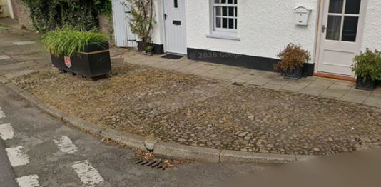
Will this affect the National Cycle Network route?
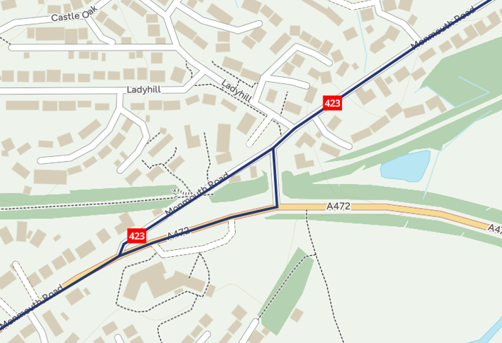
No. The National Cycle Network route (NCN 423) through Usk will remain signposted as before, following the one-way section of Monmouth Road on the route away from the town centre, and the main road junction onto the A472 on the route towards the town centre. Cyclists following the NCN who wish to use the shared use path instead of the signposted route should be careful of others using the path.
NCN routes near Usk Primary School