FAQs
- Buses to school, work, shops, and services in Caldicot
- Shops in and other destinations in Magor - there is no footway on the right-hand side of the B4245 from Undy towards Magor
- Bus services further afield (74, X74, 75, T7)
- The Undy allotments
- Tactile paving and dropped kerbs
- Sensors to extend the crossing time if someone takes longer to cross – this is a modern replacement of the ‘flashing amber’ phase of controlled crossings, adding responsiveness that means that a longer crossing time is only provided if needed, reducing the impact on traffic flows when the crossing is not in use (i.e. when someone presses the button and then decides not to cross, or crosses more quickly).
- Rotating tactile cones on the underside of the push-button units - this is now a standard additional signal mechanism for visually impaired people
- Audible signal if advised: Assessment of whether audible beeping is appropriate will be made during detailed design. If included, the beeps will sound when the crossing button is pressed, i.e. at times of high vehicle flows.
Is this the Undy to Rogiet active travel scheme?
It is part of it, but not the full route. This scheme focuses on improvements within Undy. Before funding can be secured for the Undy to Rogiet route, land and some final design details must be settled. Once settled, and in line with the strategic priorities across the county, MCC will apply for funding for the Rogiet to Undy active travel scheme. However, this consultation is about the Undy ‘gateway’ to the route, which is funded and can be constructed this year due to the urban focus of Safe Routes in Communities funding.
Can the funding be spent on the Undy to Rogiet active travel scheme instead?
No, the Safe Routes in Communities funding is scheme-specific and ring-fenced. However, the Undy to Rogiet scheme is being progressed separately using funds committed from MCC Active Travel ‘core’ funding.
How was the scheme design developed?
Development of the wider scheme began through consultation on the Active Travel Network Map (ATNM), which identified routes and missing links for walking, wheeling and cycling across the county. Areas of focus, aligned with the ATNM and Monmouthshire’s strategic priorities are progressed through the Wales Transport Appraisal Guidance (‘WelTAG’) process, that works through an analysis of the current situation, case for change, options for improvements and proposed interventions. Within Undy, issues were highlighted by several road safety incidents and concerns. The design builds on the longstanding plan for the wider Undy to Rogiet active travel scheme, the General Arrangement design for which was put to public consultation in 2024, and received overwhelming public support.
How was the scheme design developed?
Development of the wider scheme began through consultation on the Active Travel Network Map (ATNM), which identified routes and missing links for walking, wheeling and cycling across the county. Areas of focus, aligned with the ATNM and Monmouthshire’s strategic priorities are progressed through the Wales Transport Appraisal Guidance (‘WelTAG’) process, that works through an analysis of the current situation, case for change, options for improvements and proposed interventions. Within Undy, issues were highlighted by several road safety incidents and concerns. The design builds on the longstanding plan for the wider Undy to Rogiet active travel scheme, the General Arrangement design for which was put to public consultation in 2024 and received overwhelming public support.
What is a toucan crossing?
A Toucan crossing consists of traffic lights and a push-button display for people wanting to cross by walking, wheeling or cycling.
What is an inline bus stop?
An inline bus stop (also called an in-lane bus stop or bus boarder) is a bus stop where the bus stops in the traffic lane rather than pulling into a lay-by or bus bay. Passengers board and alight directly from the kerb while the bus remains in the running lane. This is appropriate for a 20mph area.
What is a shared use path?
The scheme includes widening the footway on the north side of the B4245 into a shared use path, along the section from the Toucan crossing to the Elms. A shared use path is a path for use by any mode of active travel, be it walking, wheeling or cycling, without any physical separating features or markings. The proposed shared use paths are designed in accordance with Active Travel Act guidance.
What will happen to the existing bus shelters?
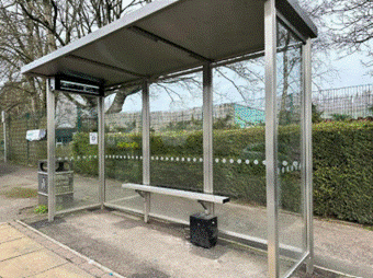
The brick-built bus shelter roof has started to crumble and has lost a tile. In light of the work being done in the area, and the fact that the bus layby will be replaced with an inline-bus-stop, the advice from MCC’s Public Transport Manager is that the bus shelter should be upgraded rather than the current shelter maintained, as the cost of maintenance is outweighed by the benefit of a more suitable, and suitably-positioned bus shelter. We would also aim to update the south side bus shelter. The updated bus shelters are proposed to be glass-panel and with a real-time information panel, similar to the new bus shelter at Tudor Court but with deeper side panels – this shelter can have an additional front panel like at Magor ‘Redwick Road’ bus stop, which may be preferred for the north side bus stop, as it is more exposed.
Similar bus shelter at Thornwell:
Is this the Undy to Rogiet active travel scheme?
It is part of it, but not the full route. This scheme focuses on improvements within Undy. Before funding can be secured for the Undy to Rogiet route, land and some final design details must be settled. Once settled, and in line with the strategic priorities across the county, MCC will apply for funding for the Rogiet to Undy active travel scheme. However, this consultation is about the Undy ‘gateway’ to the route, which is funded and can be constructed this year due to urban focus of Safe Routes in Communities funding.
Why is the route from Undy to Rogiet not included in this scheme?
It is part of it, but not the full route. This scheme focuses on improvements within Undy. Before funding can be secured for the Undy to Rogiet route, land and some final design details must be settled. Once settled, and in line with the strategic priorities across the county, MCC will apply for funding for the Rogiet to Undy active travel scheme. However, this consultation is about the Undy ‘gateway’ to the route, which is funded and can be constructed this year due to urban focus of Safe Routes in Communities funding.
Why is a controlled (Toucan) crossing needed?
The proposed crossing aims to make walking a safer and more realistic option for everyday trips.
The B4245 in Undy was earlier designed for higher vehicle speeds, and this means it’s not easy to cross the road. This maintains a vicious cycle, where pedestrians do not go near the road unless necessary, and drivers remain unaware that they are driving through a village. The scheme is funded as a Safe Routes in Communities Road Safety scheme for anyone who uses the area, whether by car or bus, or by walking, wheeling or cycling. People living in Undy need to cross the B4245 to reach:
How was the location of the controlled crossing decided?
There are four uncontrolled crossings with central crossing islands in place along the Undy stretch of the B4245. The Toucan (controlled) crossing will replace the second crossing island from the east side.
The crossing has been placed at the point where visibility, both for drivers and for people crossing, is best along this stretch. An observational study of traffic at the site identified this alignment as a main route for pedestrians. The location of the Toucan crossing will also be useful for onwards journeys for the planned Undy to Rogiet shared use path scheme.
The wider re-modelling of the road and junctions is designed to improve the other, uncontrolled crossings along this route – particularly the crossing nearest The Elms, which is not up to modern standards because it ends in the bus lay-bay.
When will the scheme be constructed?
Construction works for this scheme are planned for early 2027. Traffic management will be put in place.
How does this scheme fit with the Magor with Undy Placemaking Scheme
The Placemaking plan for Magor with Undy is in development. We will work with the Placemaking Partnership and MCC Regeneration, and do our best to reflect the materials and palette of the placemaking scheme. Funding for the construction of the Safe Routes in Communities scheme is time-limited and it will be necessary to progress this construction as soon as the consultation and design is completed. We are currently exploring how to include this area in the Placemaking scheme through the inclusion of a public art ‘gateway feature’ in line with early-stage plans for Magor.
Will the narrower junction make a difference to entering/exiting Church Road?
A narrowed junction improves the visibility splay for drivers and places the side-road crossing at a safer point for pedestrians, so that they can see drivers using the junction, and drivers make the turning at a safer speed. Near-misses are common as drivers wait in the side-road to exit. The current arrangement of the B4245/Church Road junction was designed when the speed limit on the B4245 was higher. Recorded speeds on the B4245 remain higher than the current speed limit, and this puts drivers and pedestrians at risk at the junctions.
To address concern about drivers struggling to enter and exit Church Road when the B4245 is congested (e.g. when there are issues on the wider strategic road network), a hatched box will be added at the junction of Church Road onto B4245.
When will the active travel route from Undy to Rogiet be built?
In line with the strategic priorities across the county, and once land and some final design details are settled, MCC will apply for funding for the Rogiet to Undy active travel scheme. The Undy to Rogiet route is in the Cardiff Capital Region’s Regional Transport Plan, through which funding from the Regional Transport Fund can be applied-for. As funding is sought through a competitive process against other councils, we cannot guarantee funding or give a timeline for when funding will become available but are working to bring the scheme forward for construction as a strategic priority for Monmouthshire
Will the crossing be accessible to disabled people?
Yes. This toucan crossing will make crossing the road more accessible. The crossing will include: